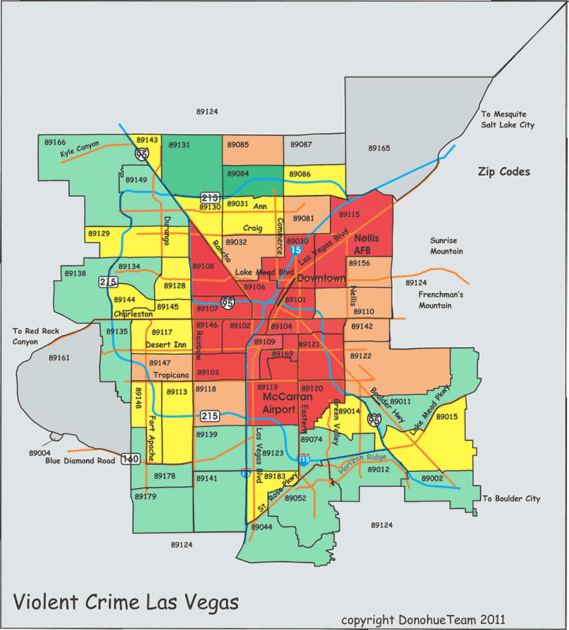
Here is a graphic that color codes the incident levels of the various zip codes in Las Vegas. We chose incidents because they most represent the actual annoyance felt by most of us by nuisance crime and disturbances. They also correlate very well with violent crime. The only significant differences will be on the borders between the classes. Some of the mixed neighborhoods have lots of nuisance but little violence and move up at the expense of the more staid neighborhoods.
Baically Green is the best 25%, Yellow the next 25%, Orange the next and Red the worst 25%
This presentation is reasonably crude but should be comparatively accurate. The incident data is compiled by taking the zip code data from Metro, Henderson and the North Las Vegas Police Department. The presentation is not the same but appears close enough. Note that it is not the same as the FBI definition so you can't compare these to the national numbers...just to each other. The populaton data is from the 2010 census. The number appear reasonable and large errors are unlikely. But the edges are probably pretty mushy.
Note that zip codes are a crude measure. The highest crime area in town 89109 actually has two completely different mechanisms...the huge number of tourist on the strip is one part and a very nasty area to the northern end the other. I think the strip piece to actually be quite safe...but the northern piece is pretty dangerous.
Unless having good local knowledge I would avoid the red and pretty much the orange. Go for the green and fall back to the yellow. For the knowledgable there are some quite nice localities in the orange and even in the red. But you need to know what you are doing.
The major sources of data are the Metropolitan Police Dept Crimeview site, The North Las Vegas Police Department and the Henderson Police Dept Crime Maps, The US Census Bureau 2010 census . The Rube Goldberg methodology used to link it all together is a proprietary product of DonohueTeam. Like Sausage making you really don't want to know how it was done. .
For the moment we are going to punt on violent crime. In general it tends to be strongly central city oriented. We have examined the CrimeView data and reached the obvious conclusion that the boys are cooking the books. There have, for instance, been no Homicides anywhere in Las Vegas for the last 60 days. We doubt that. Lilewise you apparently cannot commit a rape in the Metro jurisdiction. We also doubt that. We would try to cobble together a view but consider the data too suspect for that. The North Las Vegas data is much better but we need Metro for anything meaningful.
One of the things that drives the homeowner crazy is burglary. And burglary has a significantly different pattern than overall crime..
The pattern is vastly more distributed than crime in general. Now we see red well outside the central city and orange out to the borders. Even Summerlin and Desert Shores are impacted. And some of the rougher neighborhoods do relatively well. The overall range is about 20 to 1. And the range for the middle..the yellow and orange is less than 2:1. So a few quite good...a few quite bad...and a widely dispersed but relatively uniform middle.
Here is a similar map considering only stolen cars. The range by zip code is over 20 to 1. The strip, downtown and nearby areas are much of the problem. The red zips are over half the stolen cars.
This is all data from the Las Vegas Metro CrimeView and the North Las Vegas Police Department Crime map site.
Population data is taken from the Census for older established neighborhoods, From some 2005 updates by Sperling and from an extrapolation from housing units unsing the Assessors data base.
On this one I have no idea how Henderson plays so no guesses from me.